Standing at the edge of a canyon, you can feel the slow power of water. Rivers carve rock, move sand, and build new land, even when they look calm. Rivers are large streams of fresh water that flow downhill in natural channels. Along the way, they shape the land through erosion (wearing surfaces away) and deposition (dropping sediment).
If you’ve ever wondered where rivers begin, or why some valleys look sharp and others look wide, you’re in the right place. This guide explains what rivers are, how they form, and how rivers shape the land from their first trickles to their final meeting with lakes or oceans. You’ll also see why rivers matter so much for life, water supply, and healthy ecosystems.
Where Do Rivers Come From? Tracing Their Beginnings
Rivers start where water gathers high on the land. That high place could be a mountain, a hilly region, or even a spot where groundwater rises to the surface. The start point is often called the source or headwaters, and it’s the beginning of the river’s downhill journey.
Water reaches headwaters in a few common ways. Rain falls and runs off slopes. Snow melts as temperatures warm. Glaciers can release meltwater too. Springs add steady flow, and groundwater can feed streams from below. Because these inputs vary, some rivers flow year-round, while others run mostly in wet seasons.
Next, gravity does the rest. Small flows move downhill, first as tiny channels, then as clearer streams. These streams join together as tributaries, so the river grows bigger and more complex over time. This is like pouring multiple cups of water into one bowl. Each smaller stream adds volume, and the main river gains strength.
All of this happens inside a watershed (also called a drainage basin). A watershed is the land area that feeds the river with runoff and groundwater. If you think of the land like a roof, the watershed is the whole roof area. The river is the gutter network that collects the water.
Headwaters matter more than most people realize. They filter water, support plant and animal life, and control how quickly floods start. For a closer look at what headwaters are, and why they’re so sensitive, see Headwaters: What They Are and Why They Matter.
Even early flow shapes land. When water rushes down steep ground, it can start cutting grooves. Over long periods, those grooves become valleys that guide the river’s path.
The Three Stages of a River’s Life
As rivers travel, the slope often changes. That changes speed, width, and the way the river attacks the ground. In simple terms, many rivers pass through three stages: upper, middle, and lower course. You can picture it like a person growing up, faster and narrower at first, then wider and more relaxed later.
- Upper course: Fast, narrow, and steep. Erosion is strong, so the river cuts downward and forms steep valleys.
- Middle course: Wider and slower. The river often starts to bend more and move sideways, growing meanders.
- Lower course: Very wide and slow. Deposition can increase, and the river builds floodplains and broad channels.
Why does the river slow down? The land around it usually gets flatter. Also, the river gains more water from tributaries, so it carries more sediment. However, on gentler slopes it doesn’t always move as fast as it does near the source.
Meanwhile, the river still works. In the upper course, it focuses on cutting into bedrock. In the middle, it spends more energy moving and rearranging sediment. In the lower course, it often drops sediment when water slows or spreads out.
This stage shift is the key to understanding how rivers shape the land. The landforms you see today often reflect where the river has been most active for thousands or millions of years.
Rivers as Sculptors: The Force of Erosion
Erosion is the land-wearing part of the story. It includes processes that break rock and carry material away. River erosion happens because flowing water has energy, and because it brings solid particles with it.
One major process is hydraulic action. Fast water forces air into cracks and pushes rock surfaces apart. Another is abrasion, often described as a sandpaper effect. Sand and pebbles scrape and grind exposed surfaces. Rivers also cause corrosion by dissolving minerals in water. In addition, the river can cut down (vertical erosion) and widen its channel (lateral erosion).
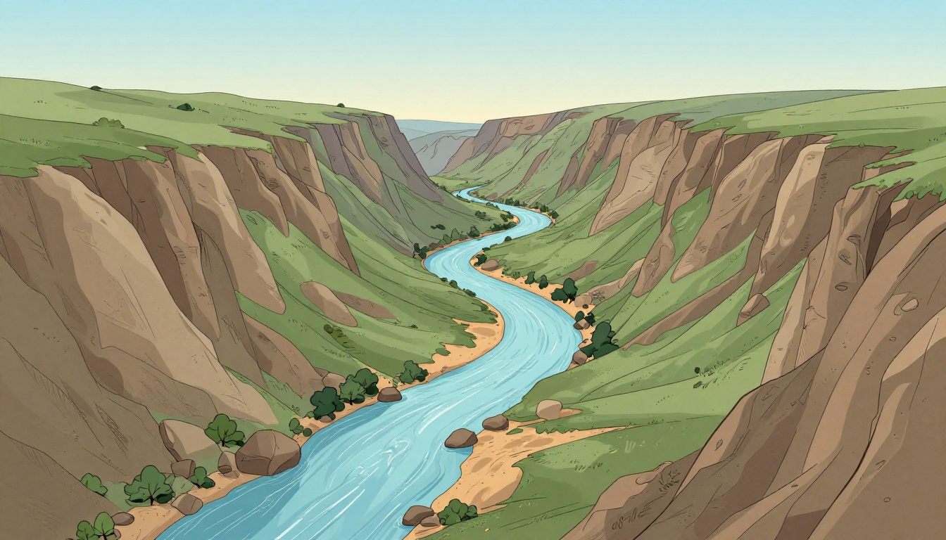
In the upper course, erosion usually dominates. Water speeds up on steep slopes, so it can slice deeper and carve sharper valleys. That’s why many upland valleys look like a wide V from the air.
Water can create sudden drops too. When softer rock sits under harder layers, the softer layer erodes faster. That difference can form waterfalls and stepped rock faces. Over time, erosion at the base can pull the waterfall upstream, so it “moves” its shape across the landscape.
River erosion can feel slow, but the forces are real. A river can grind boulders, scoop gravel, and reshape banks during storms. Recent research also points to how climate can change that pace. For example, studies tied to the USUSGS and recent work in river systems show that heavier rains can boost erosion and flood impacts, especially in headwaters.
One quick way to picture erosion is this: the river is both a tool and a messenger. It breaks down rock, then transports the broken pieces downstream, ready to do new work later.
If you want a clear view of how rivers form erosional landforms like V-shaped valleys and waterfalls, this BBC overview is a helpful starting point: River landforms (erosional features).
Valleys, Canyons, and Waterfalls Born from River Power
River erosion builds a set of landforms that look dramatic, even when the forces are simple. The most common story starts with a steep slope and focused downward cutting.
In the upper course, V-shaped valleys form from vertical erosion. The river cuts down, then erodes both sides. As time passes, tributaries can join, making the valley system more complex. In many places, repeated cutting deepens the valley and exposes harder layers.
When erosion keeps going for very long periods, it can create deep, narrow corridors called canyons. A canyon is basically a valley that got both wider and much deeper over time. Resistant rock can slow the process, but it doesn’t stop it.
Waterfalls are another erosional signature. They often form at points where hard rock sits over softer rock. The softer layer wears away, and the water drops from one rock shelf to another.
Here’s a quick comparison:
| Feature | Where it often forms | Main erosion idea |
|---|---|---|
| V-shaped valley | Upper course, steep slopes | Vertical and lateral cutting |
| Canyon | Long-term erosion over deep time | Deep incision through resistant rock |
| Waterfall | Bands of hard over soft rock | Differential erosion near the drop |
Time scales matter. It might take millions of years for a canyon to reach the size people see today. Still, the process keeps repeating. Floods add extra energy, and each event nudges the shape forward.
Rivers as Builders: Creating New Land Through Deposition
Erosion doesn’t get the whole spotlight. In the middle and lower course, deposition often becomes a bigger part of river shaping. Deposition happens when the river loses energy, slows down, and can’t carry sediment as easily.
Sediment comes in different sizes. Heavy materials drop first. Sand settles next. Fine silt and clay can travel farther, but they still settle when conditions change. That change might be slower flow, wider flow, or standing water after flooding.
This is where the river starts building landforms. When a river’s channel bends, the outside edge tends to erode more. The inside edge tends to be calmer. As a result, sand and silt can pile up on inner bends, making curves grow over time.
One of the best-known building patterns is the meander. Meanders are winding bends, and they can keep moving across a floodplain. When a meander gets cut off, the loop can become an oxbow lake.
During floods, the river spreads out onto its floodplain. As the water slows across that flat land, it drops silt. Those deposits can make floodplains fertile for crops. If you’ve heard stories about river flooding feeding farmland, this is the reason behind it.
At the river’s end, sediment can build land in another way. Deltas form where a river meets a sea or lake. If sediment arrives faster than waves and tides remove it, layers of sand and silt build outward and create a fan-shaped land area.
The river’s work can even influence history. The Nile’s flood cycles helped support agriculture in ancient Egypt, because seasonal flooding deposited nutrient-rich sediment.
In short, deposition is where rivers “plant” material back into the landscape. It’s not the same action as erosion, but it’s just as important for how rivers shape the land.
For more on alluvial landforms like floodplains and how sediment deposits along river edges, see Landforms of Alluvial Rivers.
Meanders, Oxbows, Floodplains, and Deltas Explained
Let’s turn those river landforms into clear images in your mind.
A meander grows because the outside bank often erodes more, while the inside bank receives more deposited sediment. Over time, this shifts the river’s bend farther across its floodplain. In other words, the curve isn’t just a shape, it’s an active machine for moving sediment.
An oxbow lake forms when the meander loop gets cut through. A flood or strong flow can shorten the path, leaving the loop isolated from the main channel. Without fresh flow, the old loop turns into a lake.
A floodplain is the broad, flatter land beside a river that floods during high water. Deposits build up after floods, creating layers of sediment over time. Because floodplains collect nutrients, people often farm them, even though flooding risks are real.
A delta forms at the river mouth when sediment builds faster than water can remove it. Deltas can look like branching fingers. They create new habitat for plants, birds, and fish.
Here’s a simple, side-by-side view:
| Landform | How it forms | Common clue you can spot |
|---|---|---|
| Meanders | Inner deposition, outer erosion | Winding bends across flats |
| Oxbow lakes | Cut-off meander loop | C-shaped lake off the channel |
| Floodplains | Seasonal overflow deposits silt | Flat, fertile land near river |
| Deltas | Sediment fan at river mouth | Broad land where river enters water |
One more point matters today. Climate shifts and human water use can change sediment supply. When rivers carry less sediment, deltas and coastlines can weaken. That’s one reason scientists keep monitoring rivers closely, especially in regions where water pumping and storm intensity both affect erosion and deposition.
Iconic Rivers That Transformed Landscapes Around the World
Some rivers look like they’re just there, yet they keep reshaping land. The Colorado River carved the Grand Canyon through long-term erosion, exposing rock layers and shaping steep walls. The scale is hard to ignore, and the canyon’s size reflects millions of years of river power. For a quick geographic overview, see Grand Canyon.
The Nile shows the other side of the story. Its lower course and delta regions supported farming by building floodplain deposits. Over centuries, the river’s balance of flow and sediment helped sustain large populations.
The Amazon represents a vast river system with major effects across the basin. Its size and sediment movement influence wetlands, river channels, and regional ecosystems. Even when you don’t see a single “canyon moment,” deposition and erosion still build and change the landscape in smaller ways.
Today, these rivers matter for more than scenery. They support drinking water, fishing, farms, and wildlife habitats. They also help scientists track environmental change. Recent studies and new river monitoring tools suggest that heavier rainfall patterns can increase erosion in some areas, while shifting sediment loads can alter deposition where rivers slow down.
When you understand the river stages, you start to recognize why a landscape looks the way it does. Steep regions often show active erosion. Flatter regions often show deposition at work.
Conclusion
Rivers form when water gathers high on the land and flows downhill through channels. In the upper course, they cut valleys through strong river erosion. In the middle and lower course, they slow down and drop sediment through deposition, building floodplains, meanders, and deltas.
That’s how rivers shape the land, step by step, over long time periods. And because rivers support ecosystems and human water needs, protecting them matters. Next time you pass a river, pause and ask what stage you’re seeing.